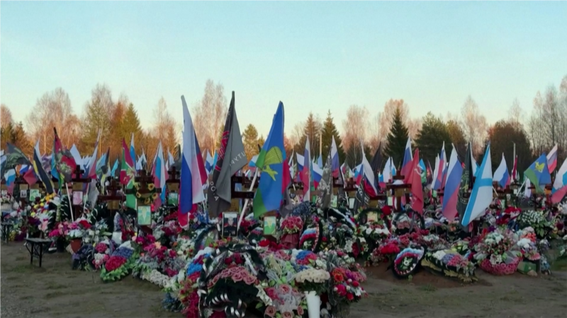
“Crimea.Realii, together with Radio Liberty’s OSINT colleagues, studied satellite images of 13 cemeteries and analyzed how much the cemeteries of the main cities of Crimea have changed since 2021”, — write: www.radiosvoboda.org
Krym.Realii together with OSINT colleagues of RFE/RL studied satellite images of 13 cemeteries and analyzed how much the cemeteries of the main cities of Crimea have changed since 2021. RFE/RL’s investigative projects and OSINT producer Rien Alyas studied nearly 400 satellite images over a four-year period.
The photos show how much cemeteries have grown: the increase in some of them has reached 10 percent in eight years, Serhiy Gapon, head of the Laboratory of Geoinformation Systems of the World Data Center for Geoinformatics and Sustainable Development, noted.
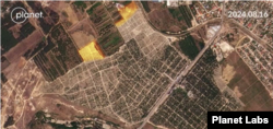
Satellite photo of Kalfa cemetery, Sevastopol. 16.08.2024
“Dynamics over the last 7-8 years, which I had to research, really, the growth is big, it’s more than 10% in terms of area. Cemeteries are really actively expanding, mostly in big cities. If these are small settlements, growth is also noticeable, but it is often difficult to say how much, because small increases on satellite images can often be mistakenly identified as something else. Again, it may not be a cemetery, but something was built near it, and it is difficult to identify it exactly as a cemetery without any observations of the places,” explains Serhiy Gapon.
According to the journalists, there is not enough places for burials in Crimea, and an acute shortage is observed in Sevastopol. The Kalfa cemetery there is going to be expanded by six hectares, and the Mackenzie Mountains – by 33 hectares. In Simferopol, the “Abdal” cemetery is almost full. There are no plans to expand it, 47 hectares near the village of Perovo have been allocated for new burials.
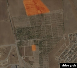
Satellite image of the Abdal cemetery, Simferopol, video footage from the issue of Krym.Realii
For each of the 13 investigated cemeteries in occupied Crimea, 30 images of good quality were found, says Rien Alyas, producer of investigative projects and OSINT for Radio Free Europe/Radio Liberty.
“We are lucky, because due to the peculiarities of the satellites, they do not receive the same picture from all corners of the globe every day. For example, one day there may be a picture of one cemetery, and then there may not be a good picture of the same cemetery for, say, two months. By good I mean clear, no clouds, good visibility. It can be received once a month. So we usually have at least one shot every two to three months. So, for each cemetery that we looked at, according to my calculations, there were about 30 pictures,” explained Rien Alyas.
See the full investigation here: